For a selection of great hiking routes that have given me a
tremendous buzz, go to my Favourite great
hikes page…
In this photo gallery section I want to share just a tiny little something of the
revitalizing and uplifting experience of my regular hiking in South-West England. Up to October
2006 (when an arthritic right knee stopped me in my tracks) I aimed to go on a single-day solo hike
every week, weather and other circumstances permitting, and my chosen routes were normally
strenuous ones, typically of some 19 — 21 miles (say 29 — 34 km) with some 1,000 metres of ascent.
On strenuous coast path routes, the mileage tended to be a bit less and the ascent anything up to
1,500 metres because of all the steep-sided valleys that are crossed.
There is only one way for you to get anything more than a faint hint of it — and
that is to do it yourself! I add to the sense of freedom and adventure of my outings by
hitch-hiking to and from my walking routes, thus enabling myself to choose satisfying linear
routes, without being limited by the times of particular buses or trains. As the bus services to
most of my hiking routes are minimal and trains more or less nonexistent, this is just as well.
This can make for extremely long days, however, and requires considerable mental and physical
stamina!
Despite the uncertainties, trials and tribulations of the hitch-hiking, I actually
preferred doing it rather than having the predictability of arranged transport — quite apart from
my not having the money to spend on fares or sharing petrol costs with anyone. I met many wonderful
and interesting people through hitch-hiking, and since I became a ‘healer’ I found that as many as
some 50% of people who picked me up had received some apparent ‘guidance’ to do so because of
particular benefit that they were likely to gain from the encounter; occasionally I even ended up
giving a mini hands-on healing session before being dropped off.
Click on a thumbnail
image to load the main picture file.
South-West peninsula (Devon & Cornwall)
North coast
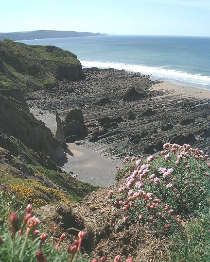
Between Bude and Widemouth Bay, the latter off to the
left. Looking approximately SSW. The pink clusters of small flowers are Thrift (Armeria
maritima), also known as Sea Pink. (May 2001)This and many parts along this coastline is a surfers' paradise, usually with large
swells coming in from the Atlantic. Bude: the vicinity of the mouth of the canal, and part of
Summerleaze Beach. Bude is a holiday resort, but it retains a remarkable sense of wildness along
its coastline. (May 2001) Looking south along the coastline to Bude and beyond. This
shows again how remarkably unspoiled this part of coastline is, considering that Bude is a quite
busy holiday resort. The town itself is just off to the left. With (usually) a considerable swell
coming in from the Atlantic, this is a very popular area for surfing, Bude and Widemouth Bay being
really busy surfing centres. (May 2001) On the coast path, looking more or less north over Speke's
Mill Mouth to St Catherine's Tor, with the white buildings at Hartland Quay just showing beyond
against the sea, from behind the hillside and outcrops left of centre. St Catherine's Tor is one of
a number of prominent mini-mountain-like prominences along the coast path in this area. Hazy
sunlight at about 5.45 p.m. (late September 2001) Just north of Speke's Mill Mouth, near Hartland Quay,
looking more or less north. The distant island is Lundy, which is featured in an unusual way in my
organ-&-tuba composition The Unknown. The
purple-flowered plant in the foreground is just a little bit of Bell Heather (Erica
Cinerea). (August 2001)
Land's End peninsula (Cornwall)
My 60th birthday falling in August 2002, I felt that summer 2002 was time to get a bit more
adventurous with some of my weekly hikes, so I've added to my repertoire of single-day outings some
hikes right at the south-west tip of England. This involves a very early rise and setting out from
my flat in central Exeter at about 6.50 a.m.; I then hitch-hike to Penzance, St Ives or elsewhere
in that area (a journey of over 100 miles), then walk some 13–19 miles on what is the most
hard-going coast path terrain that I've walked on anywhere, and then I hitch-hike back to Exeter
that evening. A long and hard day indeed — but worth every bit of the effort!
Roughly speaking, this area lies west of a north-east / south-west line from St Ives to
Penzance. Its rugged character is largely determined by the granite rock there. This granite is
part of the same underground mass of granite that breaks the surface to create Dartmoor, Bodmin
Moor, the St Austell granite and the Scilly Isles (but not Lundy, which has been produced from a
more recent granite system).On the north coast of this area the rock is granite in places, while in
other parts it's ‘metamorphic aureole’ rock — sedimentary rocks that have been heat-metamorphosed
by their proximity to the granite when it was still liquid magma deep down inside the root of the
mountain chain that was once here.
The following 4 photos are from my hike on 1st September 2002 from St Ives on the north coast
to Cape Cornwall, which is part of the little west-facing bit of coastline that also includes
Land's End.
Gurnard's Head, from the south-west. It's a joy to go out
onto that rugged headland and scramble about on its very secure rock outcrops. Gurnard's Head is
just a little south-west from Zennor. Pendeen Watch and The Enys (the nearby little island
left-of-centre) seen from the south-west.Approaching from the St Ives direction (i.e., walking
south-westwards), the last two miles to Pendeen Watch are relatively easy walking but scenically
rather commonplace, so a walk finishing there has a feeling of anticlimax about it. But as soon as
you go beyond, the coastline becomes much more rugged and exciting again. Just past the fascinating old Levant (disused) and Geevor tin mines I lost patience
with the official coast path that appeared to boringly follow a motor track slightly inland from
the real excitement, and I followed this lower-level track that led here into the most rugged and
exciting bit of coast path I've been on anywhere, with something of the feel of a narrow and rugged
mountain summit ridge traverse.
Although the track was secure, it rounded a whole series of craggy cliff buttresses, so that at
times there were exposed turns with a delicious drop at my feet, and here and there were very minor
scrambles up and down. When I first walked this stretch, it seemed a bit scary because I didn't
know what I was letting myself in for, but it turned out to be truly secure. Approaching the end of my hike: in the glare of the early
evening sun — Cape Cornwall, the next most south-westerly point on the British mainland after
Land's End, which latter is a very few miles off to the left. This view is from just below the ruin
of Kenidjack Castle. (Incidentally, the most westerly point on the British mainland isn't in these
parts at all but on the Ardnamurchan peninsula in the Scottish Highlands.)
Dartmoor area (Devon)
Dartmoor is part of a system of granite that, hundreds of millions of years ago, was molten rock in
the root of a mountain chain probably similar to the Alps.The mountains have long ago been eroded
away and the rocks that were in their root uplifted to form lower hills. On the high moor itself
the scenery is austere and spacious, and the terrain in the remotest parts is peaty and often boggy
and very fatiguing to walk on.
In the Dartmoor fringe area: the Teign Valley from the
Hunters' Path, with Dartmoor in the distance, faint in the haze. The area just a little further
along this track is known as Piddledown Common; I'm not aware that it gets more rainfall than
anywhere else in the immediate area! (May 2001) Also above the Teign Valley, on the path connecting the
high-level Hunters' path with Fingle Bridge. Prestonbury Castle, an Iron Age hill fort, is on the
top part of the prominent hill seen through the trees. (May 2001) High Dartmoor: Broad Amicombe Hole — not a hole but a pass
— with High Willhays on the skyline beyond (the highest point in Southern England — all of 621
metres above sea level). (September 2001) From on top of the largest (granite) outcrop at Fur Tor,
in remotest Dartmoor. Looking more or less north towards High Willhays. (September 2001) From on top of the largest outcrop at Fur Tor, looking
more or less west, to Hare Tor and the distant countryside of Cornwall, with Bodmin Moor forming
the skyline (not really discernible in this photo). (September 2001)